
Payl:WWI.png
Gidak-on ning maong paunang tan-aw: 800 x 333 ka mga piksel. Uban pang mga resoluyon: 320 x 133 ka mga piksel | 640 x 266 ka mga piksel | 1,502 x 625 ka mga piksel.
Tibuok resolusyon (1,502 × 625 pixels, size sa payl: 52 KB, MIME type: image/png)
Mubong sugid:
| Deskripsyon |
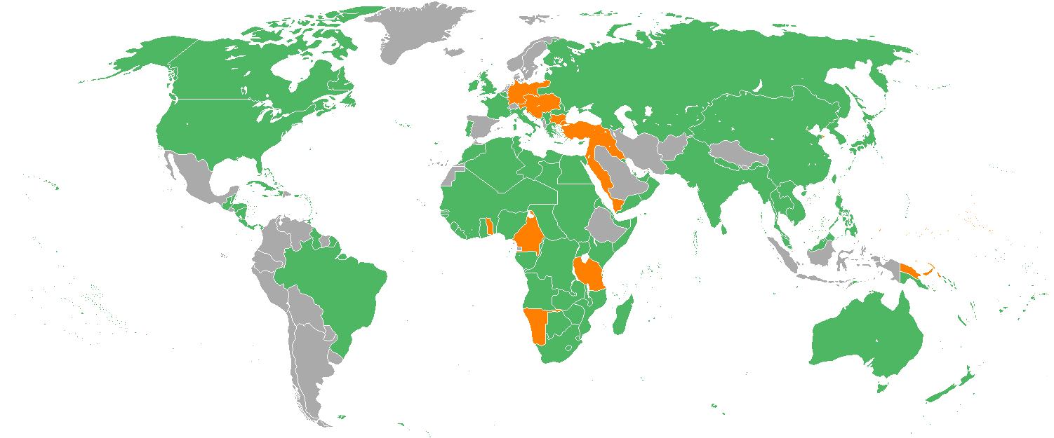
English: Map with the Participants in World War I:
Русский: Карта мира начала XX в. с границами альянсов:
Deutsch: Karte der Beteiligten des Ersten Weltkrieges:
|
| Petsa | 22 Disyembre 2005 (original upload date) |
| Gigikanan | Transferred from en.wikipedia to Commons. |
| Tagsulat | Helmandsare, Joaopais, El Jaber, Aivazovsky + Various (See below.) |
| Other versions |
|


|
This military map image could be re-created using vector graphics as an SVG file. This has several advantages; see Commons:Media for cleanup for more information. If an SVG form of this image is available, please upload it and afterwards replace this template with
{{vector version available|new image name}}.
It is recommended to name the SVG file “WWI.svg”—then the template Vector version available (or Vva) does not need the new image name parameter. |
Pagtugot
Aivazovsky at the English Wikipedia, the copyright holder of this work, hereby publishes it under the following license:

|
Gitugot ang pagkopya, pag-apud-apod o/ug pag-usab ning maong dokumento ubos sa mga termino sa GNU Free Documentation License, Version 1.2 o mas bag-ong bersiyon nga gimantala sa Free Software Foundation; nga walay Invariant Sections, walay Front-Cover Texts, ug walay Back-Cover Texts. Ang kopya sa lisensiya gilakip sa bahin nga giulohang GNU Free Documentation License. |
| This file is licensed under the Creative Commons Attribution-Share Alike 3.0 Unported license. | ||
| Attribution: Aivazovsky at the English Wikipedia | ||
| ||
| This licensing tag was added to this file as part of the GFDL licensing update. |
Original upload log
The original description page was here. All following user names refer to en.wikipedia.
- 2007-02-14 15:32 Aivazovsky 1357×628×8 (30657 bytes) Fixed northern islands of Russia and Norway, fixed borders of Russia's South Caucasus territory
- 2006-05-02 21:54 Helmandsare 1357×628×8 (30663 bytes)
- 2006-01-19 19:34 Joaopais 1357×628×8 (30415 bytes)
- 2006-01-15 12:12 El Jaber 1357×628×8 (45477 bytes) Map with the [[Participants in World War I]]: * <font color="green">''Green''</font>: [[Allies of World War I|Allies]] * <font color="red">''Red''</font>: [[Central Powers]] * <font color="yellow">''Yellow''</font>: [[Neutral Country|Neutral Countries]]
- 2005-12-22 00:53 Joaopais 1357×628×8 (30366 bytes) added Belize and the Guyanas (at the time British and French colonies)
- 2005-12-22 00:19 Joaopais 1357×628×8 (30365 bytes) Map with the [[Participants in World War I]]: * <font color="green">''Green''</font>: [[Allies of World War I|Allies]] * <font color="orange">''Orange''</font>: [[Axis Powers]]
Kaagi sa payl
I-klik ang petsa/oras aron makit-an ang hulagway sa payl niadtong panahona.
| Petsa/Takna | Thumbnail | Mga dimensyon | Tiggamit | Komento | |
|---|---|---|---|---|---|
| kasamtangan | 18:19, 27 Pebrero 2014 | | 1,502 × 625 (52 KB) | Grachifan | major update |
| 18:18, 27 Pebrero 2014 |  | 1,502 × 625 (60 KB) | Grachifan | major update | |
| 18:17, 27 Pebrero 2014 |  | 1,502 × 625 (54 KB) | Grachifan | major update | |
| 03:28, 31 Marso 2013 |  | 1,357 × 628 (45 KB) | OgreBot | (BOT): Reverting to most recent version before archival | |
| 03:28, 31 Marso 2013 |  | 1,357 × 628 (30 KB) | OgreBot | (BOT): Uploading old version of file from en.wikipedia; originally uploaded on 2006-05-02 21:54:27 by Helmandsare | |
| 03:27, 31 Marso 2013 |  | 1,357 × 628 (30 KB) | OgreBot | (BOT): Uploading old version of file from en.wikipedia; originally uploaded on 2006-01-19 19:34:32 by Joaopais | |
| 03:27, 31 Marso 2013 |  | 1,357 × 628 (44 KB) | OgreBot | (BOT): Uploading old version of file from en.wikipedia; originally uploaded on 2006-01-15 12:12:07 by El Jaber | |
| 03:27, 31 Marso 2013 |  | 1,357 × 628 (30 KB) | OgreBot | (BOT): Uploading old version of file from en.wikipedia; originally uploaded on 2005-12-22 00:53:03 by Joaopais | |
| 03:27, 31 Marso 2013 |  | 1,357 × 628 (30 KB) | OgreBot | (BOT): Uploading old version of file from en.wikipedia; originally uploaded on 2005-12-22 00:19:12 by Joaopais | |
| 23:42, 4 Enero 2013 |  | 1,357 × 628 (45 KB) | Tfts | marked Albania as a neutral state |
Mga paggamit sa payl
Ang mosunod nga mga panid misumpay niining payl:
Global nga paggamit sa payl
Kining ubang wiki naggamit ning maong payl:
- Paggamit sa als.wikipedia.org
- Paggamit sa ar.wikipedia.org
- Paggamit sa az.wikipedia.org
- Paggamit sa be.wikipedia.org
- Paggamit sa bg.wikipedia.org
- Paggamit sa ca.wikipedia.org
- Paggamit sa ce.wikipedia.org
- Paggamit sa da.wikipedia.org
- Paggamit sa de.wikipedia.org
- Paggamit sa en.wikipedia.org
- Paggamit sa eo.wikipedia.org
- Paggamit sa es.wikipedia.org
- Paggamit sa eu.wikipedia.org
- Paggamit sa fy.wikipedia.org
- Paggamit sa he.wikipedia.org
- Paggamit sa hr.wikipedia.org
- Paggamit sa hsb.wikipedia.org
- Paggamit sa hy.wikipedia.org
- Paggamit sa id.wikipedia.org
- Paggamit sa ja.wikipedia.org
- Paggamit sa kk.wikipedia.org
- Paggamit sa ko.wikipedia.org
- Paggamit sa la.wikipedia.org
- Paggamit sa lld.wikipedia.org
- Paggamit sa ms.wikipedia.org
- Paggamit sa nds.wikipedia.org
- Paggamit sa nl.wikipedia.org
- Paggamit sa pa.wikipedia.org
- Paggamit sa pl.wikipedia.org
- Paggamit sa pt.wikipedia.org
- Paggamit sa ro.wikipedia.org
- Paggamit sa ru.wikipedia.org
- Paggamit sa sh.wikipedia.org
- Paggamit sa si.wikipedia.org
View more global usage of this file.